ROS Resources: Documentation | Support | Discussion Forum | Index | Service Status | ros @ Robotics Stack Exchange
Ask Your Question
0

How to evaluate the performance of the pose estimation of Hector_Mapping

asked 2012-12-17 01:54:11 -0600

Astronaut gravatar image

Hello

I would like to know how to evaluate the estimated pose of the hector mapping. Im using IMU and Laser range finder as a sensor package. So, is there any method to valid/evaluate the performance of the estimated pose by hector_mapping. How to know if the estimated pose is accurate?? Any explicit or implicit method of the evaluattion of the hector_mapping pose???

Thanks

edit retag flag offensive close merge delete

2 Answers

Sort by ยป oldest newest most voted
2

answered 2012-12-17 04:57:15 -0600

dornhege gravatar image

There are some approaches to evaluate SLAM algorithms.

The most basic measure is: Make a map an look at it.

There exist some quantitative methods:

  • Some can be found in the program of a SLAM evaluation workshop.

  • You can find some information for using relations as an evaluation measure.

  • The Robocup Rescue League uses mapping fiducials to see how good a map is.

edit flag offensive delete link more

Comments

Ok. Thanks. . Just a comment, IS there to find a documentation how the robot pose in Hector_mapping was obtained?? I used the pose of the hector _mapping to obtained other parameters like velocity, so would like to know more about iAlso to understand the relations of the sensor sources and the pose

Astronaut gravatar image Astronaut  ( 2012-12-17 08:37:29 -0600 )edit

My sensor package consist of IMU and laser range finder

Astronaut gravatar image Astronaut  ( 2012-12-17 08:37:57 -0600 )edit

Sure, they list the paper on the Wiki page.

dornhege gravatar image dornhege  ( 2012-12-18 02:22:04 -0600 )edit
3

answered 2012-12-17 05:28:54 -0600

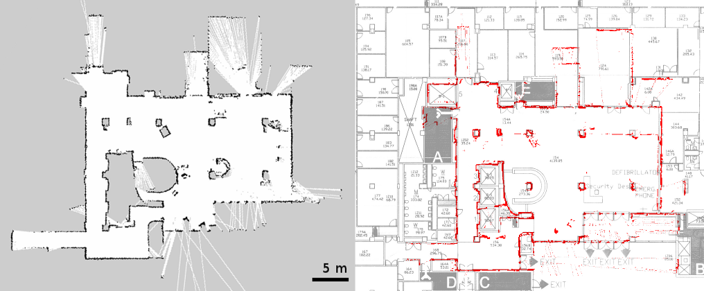
A slightly stronger variation of the make a map and look at it method that dornhege described: make a map and overlay it (with the correct scaling) on a blueprint of your building. If you're in a university, you can typically get those from the Facilities and Operations people.

While this is not a quantitative method, it is straightforward and fairly informative.

Here's an example that we've used in a paper:

image description

edit flag offensive delete link more

Comments

1

That's a good point. For outdoor mapping Google Map -> Canny also works quite well. Fig. 5 in http://ais.informatik.uni-freiburg.de/publications/papers/kuemmerle09auro.pdf gives an example of a canny "map".

dornhege gravatar image dornhege  ( 2012-12-17 05:54:36 -0600 )edit

Question Tools

Stats

Asked: 2012-12-17 01:54:11 -0600

Seen: 459 times

Last updated: Dec 17 '12